
Overview Of The Padma Multipurpose Bridge Project
Let's See The Topics
At a Glance – The Padma Multipurpose Bridge In BangladeshName of the Project: PADMA MULTIPURPOSE BRIDGE PROJECT Loan Financing Agencies: Government of Bangladesh decided not to take loan from funding Agencies on 09 July 2012 & took decision to complete the project from GoB Fund/Budget. Concerned sector: Asian Development Bank (ADB) Executing Agency: Bangladesh Bridge Authority (BBA) Overall Padma Bridge Cost: BDT 287933.88 Million or, USD 3.692 Billion (Including VAT and IT) Project Area and Location: The Padma Multipurpose Bridge Project area is located in the south-central part ( Munshiganj, Shariatpur and Madaripur district) of Bangladesh. The left bank (north bank ) on Mawa side is located in louhajong upazilla of munshiganj district whereas the right bank (south bank) on Janjira side located on Janjira upazilla on Shariatpur district and Shibchar Upazilla of Madaripur District. Project Duration:
|
The Padma Multipurpose Bridge
The proposed Padma Multipurpose Bridge Design Project (PMBDP) is a vital important large scale infrastructure project in the communication sector. Execution of the project will essentially benefit different areas of the economy of Bangladesh. The Padma River isolates the southwest zone of Bangladesh from other parts of the country.
There have been considerable developments and improvements in the road organization of the southwest zone of Bangladesh, yet this zone stays past the advantages of an integrated road network because of the absence of a bridge over the Padma River. Presently, the connection between the southwest zone and the rest of the country across the Padma River is only by ferry.
The limit of ferry services is very limited and the waiting time at ferry ghats is over 2 hours for transports and light vehicles and over 10 hours for trucks. Furthermore, the Riverbanks of the Padma are truly shaky, particularly on the south side (Janjira) and the River width changes every now and again, leaving the methodology ghats occasionally defective. The development of existing ferry terminals is made troublesome by these conditions.
The proposed bridge will give direct connections between two significant seaports of the nation and associates missing connections for the Tamabil-Sylhet-Sorail-Kanchpur-Dhaka-Mawa-Bhatiapara-Norail-Jessore Benapole parkway and will be a basic piece of the Asian Highway No 1 and Trans-Asian rail route network contexts.
The distance from Dhaka to practically all significant destinations in the southwest area will be diminished by 100 kilometers (km) or more, which will acquire impressive investment funds traveler and product development time and expenses, just as vehicle activity and upkeep costs while protracting the valuable existence of vehicles, investment funds in fuel utilization, and decreasing the air emission.
Padma Multipurpose Bridge Project Area and Location
The Project area is located in the south-central part (Munshiganj, Shariatpur, and Madaripur Districts) of Bangladesh. The specific area at north side (Mawa) of the Padma Multipurpose Bridge comprises Lauhajang and Srinagar Upazila in Munshiganj District whereas at south side (Janjira) of the bridge comprises Janjira Upazila under Shariatpur District and Shibchar Upazila under Madaripur District. The Project influence area will broadly cover –
- The corridor of the Asian Highway (Tamabil-Sylhet-Sorail-Kanchpur-Dhaka-Mawa-Bhatiapara-Norail-Jessore-Benapole),
- The corridor of Trans-Asian railway network and the railway missing link from Gendaria-Mawa through the bridge to Bhanga-Kashiani-Narail-Jessore-Benapole
- The Charland in up and downstream of the Padma River.
In addition, the network for utility connections, they are-
- High pressure gas transmission line will link the Bakhrabad Gas Field to Siddirganj to augment gas supply then through an off-take valve at Langalbandh of Sonargaon Upazila under Narayanganj District will be the source point for gas supply to Mawa, which will cross the Bridge (on the lower deck) and will follow upto Khulna for completing the proposed National Gas Grid,
- High voltage power transmission line will source power from Siddirganj in Narayanganj district then Mawa and cross the River (running parallel and away from the bridge) then to Khulna, and (c) optical fiber telecommunication cable on the lower deck of the bridge.
Components of the Padma Multipurpose Bridge
- The Padma Multipurpose Bridge (Main Bridge) (6.15km long) and transition structures (Bridge End Viaducts).
- Bridge Connecting Approach Roads (about 2.3km at Mawa side and 12.8km at Janjira side) and associated structures
- Spans: Total 41nos.
- 2 transition pier at landward ends and 40 Center piers
- 6 bridges, 14 culverts, 7 underpasses, and 11 junctions;
- Toll Plazas 2 (1 at Mawa and other at Janjira);
- Construction Yards 2 (area at Mawa= 81ha and at Janjira=78ha);
- Service Areas 2 (area at Mawa=27.2ha and at Janjira=63.7ha);
- 4 Resettlement Sites (2 at Mawa: RS02: Jashaldia with area 13.96ha, RS03:
- Kumarbhog with 15.46ha and 2 at Janjira: RS04: Paschim Naodoba with area 19.95ha and RS05: Bakhorerkandi with area 18.45ha, respectively);
- Future provision of Railway on the lower deck of the bridge; and
- Provision of utility Crossings (high pressure gasmain and optical fiber telecommunication cable).
Detailed Design
The Padma Multipurpose Bridge Project will set up the detailed engineering design and all offering documentation for the entirety of the works based on the selected final scheme design using state-of-the-art techniques, methods, and principles to deliver an effective, vigorous, and buildable plan that consents completely with the concurred plan models in similarity with international codes and standards and, where significant, distributed plan and detailing guides. The definite designing plan will show what suspicions have been made with respect to the development succession and strategies and, where important, suppositions in regards to crawl, shrinkage, and other time-subordinate impacts.
The design and specifications will express the pre-cambers required or on the other hand indicate necessities for the project worker to decide pre-cambers or projecting bends. As a component of point by point designing plan, illustrative designs, plan determinations, and construction details will be ready, based on which the task quote and the O&M quote will be updated.
Main Bridge
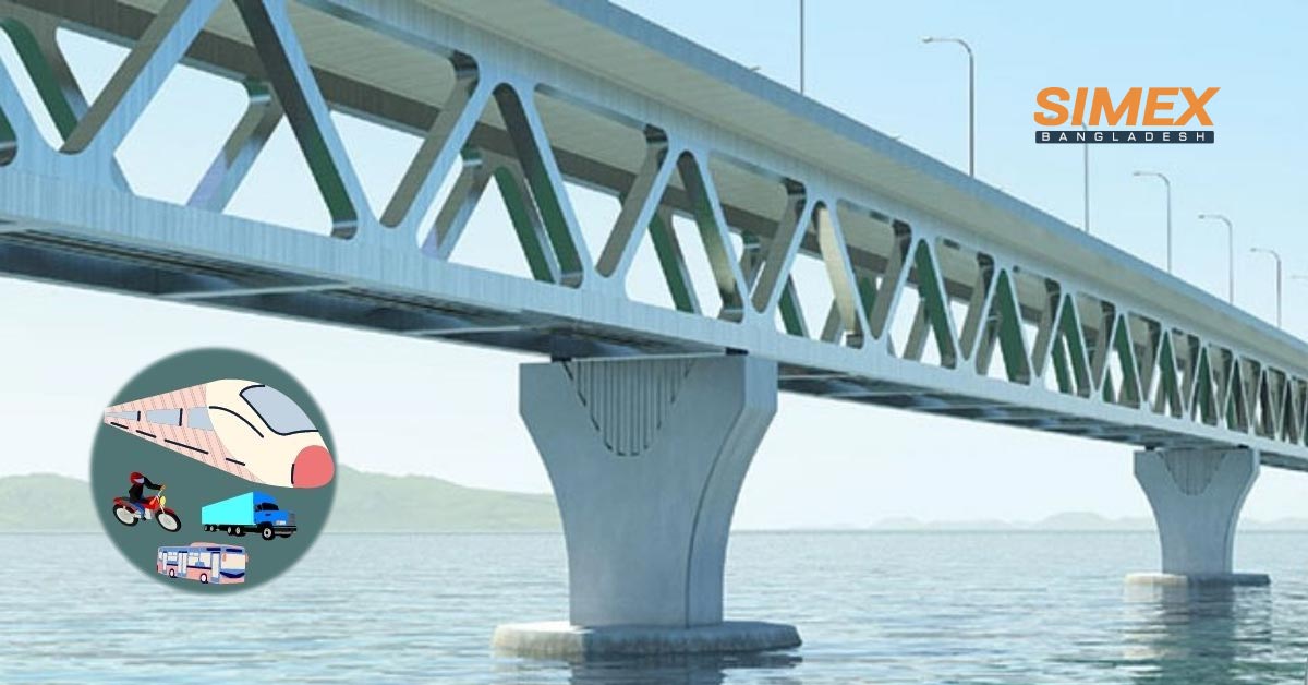
The main purpose of the main bridge over the Padma is to allow level crossing of road and rail traffic and take the full advantages of integrated continuous fast communication network. It has the following key features/characteristics:
- The total length of the bridge is about 6.15km of 22.5m width; the bridge will have horizontal and vertical curves with vertical gradient being 4% for pavement and 0.5% for the future railway.
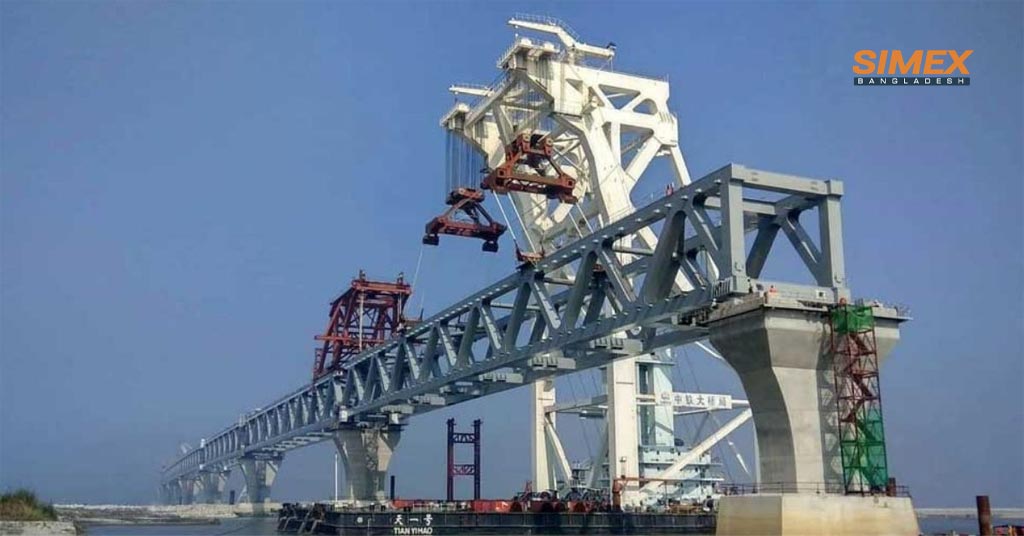
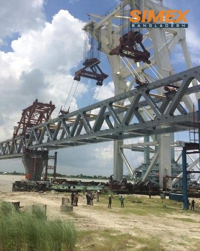
- Two level composite steel truss of multiple regular spans each of 150m across the Padma River. The deck cross-section consists of a concrete top slab connected compositely to the upper chord of a steel truss.
- The two-level superstructure carries dual two lane carriageways with hard shoulders at the upper level and the provision of a single broad gauge railway track at the lower level and The superstructure of the bridge will be supported on concrete piers at 150m spacing that will have deep pile foundations.
River Training Works
The other main purpose of River Training Works (RTW) on both sides of the River at bridge location is to protect the River bank from erosion so that the bridge, approach roads, BEF and railways can remain integrated and functional during the operation and maintenance phase of the Project. River Training Works 14 km (8.7 mi) length.
Approach Roads
The following design details for the approach roads are considered:
- 2.3km long approach road in the Mawa side and 12.8km long approach road of
- 23.6m width in the Janjira side totaling 15.1km;
- An approach road viaduct of 2.032km for Mawa side and of 1.915km for Janjira side.
- In the Mawa side the existing two-lane road will be widened to a four-lane approach road;
- In the Janjira side new approach road will be built with 6 bridges, 14 culverts, 7 underpasses, service roads and 11 road-junctions;
Bridge-end-Facilities
Different BEF is recommended in the design to provide maximum advantages to the user and the operation.
1. Toll plaza on both sides and spare toll plaza at Janjira side
About 17.5ha total land area is allotted for toll plaza in both sides. Total area of the toll plaza in Janjira side is about 4.78ha. There will be 6 toll gates in each side with a total area of 72m2. There will be a two-storied office building with amenities, one operation and fire station building, one police station and one weigh bridge station. In addition, there will be a spare toll plaza at Janjira side. This will have office, accommodation and a small laboratory and for the mobilization of construction supervision staff construction stage will be used at early. For an emergency response station the site will be further developed to ensure proper handling of the accidents and disasters on the bridge of any nature. In future this will be equipped with necessary emergency equipment.
2. Service Area
A service area will be built of 27.03ha at Mawa side and in Janjira side the area is 63.7ha. Each service area will have offices for consultants and BBA, laboratory, houses for engineers, and single accommodation for engineers, sports areas and associated facilities during construction. Both service areas will be designed to have police station, restaurant, food court, shops and kiosks, mosque, visitor center and observation tower, visitor parking, staff parking, electrical substations, consultants and BBA project office, control and maintenance office, club house/entertainment precinct, medical clinic, senior staff houses, senior staff accommodation, engineers house, single engineers accommodation, and junior staff house.
3. Construction Yards
Two construction yards (one at Mawa side 81 ha and the other at Janjira side, 78ha) are required for providing contractors with the necessary lands for carrying out construction works and storage of construction materials. Sites for construction yards identified during the feasibility stage are not usable anymore. At detailed design stage of the project it is evaluated that site at Mawa side is not conducive for use as construction yards because of access problems to this site from the Padma River. Hence, an alternative site is assessed and finalized.
4. Railway
At the initial stage, railway on the bridge connecting two stations at the bridge ends was considered. However, the scope has been revised to provide the future provision of the railway. The total length of the future railway structure is 15.85km including those over main bridge (6.15km), railway viaducts (2.789km at Mawa side and 2.899km at Janjira side) and approach railway (2.45km at Mawa side and 1.7km at Janjira side) connecting two stations at bridge ends.
The current scope covers the provision of railway in lower deck of the bridge including railway viaduct. The purpose of long railway viaduct is to allow rails gradually ride the main bridge at a very soft gradient of 0.5% from the railway line that comes along the approach roads, along with free-passing of vehicles and others under the viaducts. The superstructure will be built of simply supported 1,600mm deep posttensioned pre-cast concrete I-Girders with a cast in-situ composite deck slab.
5. Utility Crossings
The main utilities to be accommodated include the power transmission line (400kV) and the gas main. The gas main is simply supported within the truss with vertically orientated loops to accommodate the necessary movements. At the two transition piers, the gas main is brought down to ground and is carried underground away from the bridge structures. The bridge will be “gas main ready” as the gas main will not be installed for some time after construction is completed.
6. High Pressure Gas mine
A 30in diameter high pressure gas mine on the bridge is considered with a separate corridor. Pigging system by installing scrapping trap stations, installation of shut off valves with venting facilities, expansion loops along with the gas pipeline to accommodate expansion and contraction of above ground pipeline, cathode protection (CP) system to protect pipeline corrosion, and SCADA facilities at both end of the pipeline will be provided. In addition, necessary safety, operation and maintenance facilities will be considered during design, construction, and operation phases as per Natural Gas Safety Rules, 1991 (as Amended in 2003) and other International Standards.
7. High Voltage Power Transmission Line
A 400kV high voltage power transmission line will be built, which will be either on the bridge or run parallel and away from the bridge with the following features:
- The total length of the line is assumed to be 6.5km
- The new transmission line would consist of self-supporting towers, 6 towers in the middle of river and 2 on either side on the bank. Nominal span of 830m
- The height of river crossing towers would be 100-105m all, with based width at the foundation level to be around 20-25m. These towers would provide a clearance of 18.65m above the water level
- The river crossing towers would be provided with climbing ladders with a fall arrest system. Since the total height of the structures is above 80m, the climbing ladders shall be furnished with work platforms at 20m intervals
- Standard I-string suspension insulators would be used
- Two anchor towers on either side of the line would be installed on the bank with the terminal arrangement. One OPGW and the one standard earth wire would be installed
- Due to structure heights, air craft warning spheres would need to be installed on the earth wire.
8. Optical Fiber Cable
A provision for lying of 10cm diameter duct with proper clamping system and in a firm body for carrying out optical fiber cable by the side of the bridge at the first level of the superstructure. Provision for pulling and jointing of optical fiber cable and hand hole (1.5m x 1.00m) will be provided at an interval of each 2.00km.
Objectives and Targets
The Padma Bridge will connect Louhajong, Munshiganj to Shariatpur and Madaripur linking the south-west of the count, to northern and eastern regions of Bangladesh.
1. Economic and Financial
The Economic and Financial objective is to reduce rate of poverty rate higher than historical trends in the past 2 decades and yield an economic intimal rate of return of 21% in line with the results of the commotional approach.
2. Poverty reduction
The southwest zone has one of the highest priority rates in Bangladesh. According to the household income and expenditure survey conducted in 2005.So the objective is increasing the gross domestic product growth rate by 1.2% and the regional growth rate in the southwest zone by 3.5%. Generating 743.000 person-years of additional employment and thereby contributing 1.2% of the total labor market of Bangladesh.
3. Socioeconomic objective is as follows-
- Improve access to socioeconomic services.
- Increase employment opportunities and
- Improve transport services that will reduce poverty in the region.
4. Gender action and public health action objective
- Making opportunity of livelihood reconstruction and income restoration programs,
- Employment of unskilled and semiskilled labors in civil works construction.
- Creating gender-equitable process of consultation and information dissemination in relation to dis-settlement and rehabilitation,
- Gender inclusive mechanism to redress grievances.
Self-Financing in Padma Multipurpose Bridge
Bangladesh being developing country always needs adjustments both in its development and construction activities as well as in the capacity to implement them. The Padma Bridge project will involve the direct resource of cost, which was later estimated to be around Take 30000 Million padma bridge finance and indirect cost be the impact on other economic activities and the balance of payments as a result of diverting resources, both in terms of local and foreign currency.
ADP financing of the bridge will make it relatively expensive because the ADP budgets of the country are mostly financed through direct government borrowing from the banking sector at interest rates of up to 11-12%. He suggested issuing sovereign bonds in the local market (including zero-coupon convertible bonds) instead of funding from ADP budget and subsequently allowing those bonds to be traded on a secondary market so that it will help create a more liquid sovereign bond market in our country. That in turn will enable the development of a vibrant corporate bond market, lowering the cost of funding as well as systemic risk for local businesses that are currently over-reliant on bank borrowing.
He also further analyzed that this project will require a huge amount of foreign currency, which will be costly to convert into foreign exchange if the funds are raised locally. The author detailed that 60-70% of the project cost will be in the form of imports of capital machinery, materials, consultancy services which will in turn create huge demand for US dollars resulting a robust imbalance in balance of payment. Although raising foreign currency from Sovereign Bonds at a high interest rate of 6% does not seem to be economically viable for the bridge project.
Padma Bridge is the name of endless opportunity for Bangladesh. This is the opportunity of linking the districts of south-west region and achieving economic prosperity of the country. Constructing Padma Bridge with own resources has both challenges and opportunities for the nation. The challenges may be: a) inflation may rise; b)keeping allotment in national budget for Padma bridge may risk creating budget deficit that consequently may usher in new economic crisis; c)obtaining resources from the banks and expatriates’ reserve fund may create liquidity crisis and as a result taka may be devaluated. Most importantly he praised the government’s move to finance the project using own resources and offered some very important suggestions: using PPP, issuing bond, withholding the less important projects and undertake some austerity measures in govt. spending etc.
A financial benefit–cost analysis was undertaken over a 30-year period following the opening of the Padma Bridge. All costs and revenues were expressed in nominal prices. Surplus revenues from operation of the Jamuna bridge were incorporated in them analysis. 8. As the timeline for building a railway line across the Padma Bridge has yet to be confirmed, the corresponding cost and benefits were not included in the analysis.
However, the implementation of the railway line during the life span of the bridge, assuming a bridge life of 100 years, is highly likely. A financial analysis assessed the viability of the proposed project investment based on the capacity of Bangladesh Bridge Authority (BBA) to generate sufficient revenues to cover the capital costs of the project. The analysis was carried out on an incremental basis, using the discounted cash flow method and measuring the financial internal rate of return of the project.
Risk Analysis of the Padma Multipurpose Bridge
The objectives of the scoping process are to identify significant-
- Environmental and social issues early enough to feed them back to the planning team before engineering decisions are made,
- Biological factors that will be influenced during the pre-construction phase, construction, and O/M stages of the Project, and
- Possible impacts must be properly analyzed and handled for mitigation and management at various phases of the project.
Harmonized Environmental Safeguard Requirements
A harmonized framework for environmental safeguard is prepared to address the environmental safeguard requirements of the Government as well as that of the Co-financers, World Bank, ADB, IDB and JICA. The scoping procedure considers the requirements of this harmonized framework.
Project Information
A detailed review of the proposed civil works and facilities during pre-construction, construction and O/M stages of the Project is made to identify relevant environmental issues. Induced regional development due to the Project and associated development works are also considered for scoping analysis.
Other Studies and Past Experiences
A detailed review of the proposed civil works and facilities during pre-construction, construction and O/M stages of the Project is made to identify relevant environmental issues. Induced regional development due to the Project and associated development works are also considered for scoping analysis.
Public and Stakeholder Consultation
Views, suggestions and concerns expressed by affected people during 8 large public consultations and 13 focus group discussions held in the Project areas, and discussions with the experts and various stakeholders (government and non-government organizations, and co-financers) were the key input to the scoping study.
Baseline Information
The following social and environmental studies carried out under the Project are used for scoping analysis:
- Social and Resettlement
- Environmental quality (water, noise, air, riverbed material)
- Aquatic life and fish
- Flora and fauna
- Wildlife
- Land use
- Char land
- Topography, geology and hydrological modeling
- Climate change
Project Boundaries
The scoping analysis considered both direct and indirect areas of Project’s influence as spatial boundaries of the Project.
Identification of Environmental Impacts
The environmental components considered incorporate physical, ecological, and financial environment and environmental quality. A connection network is created between Project activities and the environmental components to recognize ecological parts that will be affected because of various Project exercises during different phases of the Project. The lattice contains all Project exercises during the pre-construction, construction and post-construction phases of the Project.
The pre-construction activities include land acquisition, development and construction of resettlement sites. The construction activities include construction of main bridge, RTW, approach roads, bridge end facilities, and construction yards. The post-construction activities include O/M of Project, development of associated components (widening of N8, railway connectivity, and public utility crossings) and induced regional development.
Action Plan
Resettlement Action Plan
To address and mitigate the adverse impacts on life’s and livelihood of the Affected Persons (APs) due to acquisition/requisition of lands for the Padma Multipurpose Bridge Project, Resettlement Action Plans (RAPs) was prepared. The RAPs were prepared based on major Components of the Bridge as mentioned below:
- Development of Four Resettlement Sites: RAP-I
- Main Bridge, Approach road, Service Area and Bridge End Facility: RAP-II
- River Training Works: RAP-III
- Construction Yard at Janjira including Temporary Resettlement Site, Janjira: RAP-IV
- Construction Yard at Mawa: RAP-V
Environmental Action Plan
Environmental Action Plan (EAP): During three implementation stages of project, under EAP an Environmental Management Plan (EMP) has prepared to minimize or avoid high and medium ranked hostile environmental impacts as identified in the EIA – Pre-construction,-Construction, and Operation Maintenance. Each adverse impact during implantation stages is addressed in the EMP as follows-
- Dredged Material Management Plan- Dust management- Top Soil Stripping, Storage and Reuse- Noise and vibration management-
- Emergency Response Plan
- Development of Hydro-meteorological station
- Community Environmental Management Plan of Resettlement Sites (RS)
- Tree Plantation and Greenbelt Development Plan.
- Biodiversity Management Plan (Wildlife baseline monitoring including hilsha fish and Dolphin migration monitoring) – Padma protected Sanctuary, Development of Visitor center- Resettlement Action plans- Public Health Action Plan
- Income and livelihood Restoration Plan
- Formation of Environmental Enhancement Fund.
Socio-economic Profile of the Project Area
About 30 million people or 23% of the total population of Bangladesh lived in the Southwest region as of 2001. The population density and average population growth rate of the Southwest region are lower than those of the Northeast region. The Gross Regional Product (GRP) of the Dhaka Division accounted for about 38% of total national GDP while the Per Capita GRP was also the highest in FY 2000. On the other hand, the total GRP of both Khulna and Barisal Divisions was only 17.4% of total GDP. Agriculture and fishery have traditionally been the major sectors in the Southwest region. The share of agriculture and fishery in the GRP was 38% and 32.7% for Barisal and Khulna Divisions respectively, higher than the average of 25.5% for Bangladesh in FY2000.
The most active shrimp farming center is in Khulna Division, particularly in Bagerhat. About 80% of the national shrimp production comes from the Southwest region. The main industry in the Southwest region was jute processing. However, this sector has been declining, due to a drop in global market prices. The Mongla Export Processing Zone (MEPZ) is partly under operation in the area adjacent to Mongla Port.
Benefits
The quantified benefits of the Padma Multipurpose Bridge investment are measured incrementally to the without-bridge case, i.e., they are measured as the difference between the without- project and the with-project cases. The economic analysis considers-
- Benefits arising from annual savings in vehicle operating cost (VOC) and travel time to existing passengers and freight crossing the Padma River
- Benefits accruing to new trips generated by induced demand. Other types of benefits include the (i) savings in costs associated with operation of the ferry services, (ii) capitalized value of service area land
- Capitalized value of agricultural land to be reclaimed or protected by river training works, and
- Revenue from bridge structure usage fees levied on utilities.
VOC is used to place an economic value on cost savings, incorporating various factors: fuel, tires, and maintenance, etc. For the economic evaluation, unit VOC was derived from the Road User Cost Annual Report, 2004–2005. Total VOC was disaggregated into fuel and nonfuel components, which were then escalated to 2009 values by the increase in average petroleum spot price6 and the consumer price index. The VOC for the different vehicle classes was then weighted using the vehicle proportions observed during a traffic survey in May 2009 to determine VOC for trucks, buses, and light vehicles. A measure of value of time is used to convert travel time savings into a monetary value.
Travel time costs for passengers and crew were sourced from the Roads and Highways Department and for freight in transit from an ADB technical assistance report. These were then adjusted to 2009 prices by estimating the increase in general wage rate index using data sourced from the Bangladesh Bureau of Statistics and ADB.
Construction of the Padma Bridge is feasible from a macro-economic perspective. For the development of the regional economy and to the reduction of poverty, it will contribute. At the same time, the contribution of the bridge has great significance in terms of developing an international transport corridor. Therefore, this should be an urgent project to be implemented at the earliest opportunity.
The success of the Project completely depends on whether smooth and timely land acquisition and relocation of the affected people will be implemented. In order to attain this goal, the project execution agency should take appropriate measures during the detailed study and implementation periods. For example, a resettlement action plan (RAP) is critical to safeguard the rights of the affected peoples such as the replacement value of their assets, resettlement, livelihood restoration, and additional assistance to marginal and vulnerable groups.
To ensure the maximum contribution of the Padma Bridge in promoting the regional economy, the Government shall take the following actions:
- Expand the capacity of the existing NH-8 connecting to the Padma Bridge to four lanes before the traffic volume exceeds its capacity.
- Exaggerate the local road network in the Padma Bridge area of influence.
- Invite enterprises and factories to relocate to the Padma Bridge area of influence.
- Utilize the service area for the promotion of local working opportunities and small industry.
- Improve the proper entrance and exit routes to and from Dhaka.
The Government shall take the following actions to contribute further to the boosting of the Sub-Regional Economy encompassing both national borders and the international transport corridor of the Padma Bridge:
- Conclude an international contract to promote smooth cross-border transport.
- Sanction the necessary regulations and laws related to international treaties and to train officials regarding such regulations and laws.
- Complete the necessary facilities of land ports, such as Benapole.
- Introduce plans to promote domestic forwarders.
Conclusion
The Padma Multipurpose Bridge is the first of its kind in Bangladesh. It will be a bridge that connects two sides of the Padma River and it will have special features like four lanes, sidewalks for pedestrians, and bike paths. This blog post is meant to inform you about this new project that has been approved by the government in Bangladesh. The goal is for this bridge to improve transportation between these two parts of Bangladesh as well as help with flood mitigation. If learn more about Padma multipurpose bridge project, let us know! As a renowned bridge construction company in Bangladesh, we always collect this project’s information.